
Mount Lafayette, Franconia ridge loop, January ’14.
Three summits in one day, with Rusty McStix.
The summit was a complete whiteout. We walked the ridgeline between Haystack and Lafayette for an hour, visibility of about 20 feet, barely able to see the cairns, losing them now and then in the fog and blowing snow. Since it was a ridge we weren’t likely to lose our way, as long as we didn’t take the fast way down. About twenty minutes in to the ridge walk Rusty declared that we’d found Lincoln, though the suspected marker was out of reach, buried under a foot of snow. Of course soon after we found ourselves obviously climbing up higher, crampons slipping on snow covered scree, and decided this must be Lincoln. At least when we made it to Lafayette we were sure. We found the sign. We took a picture next to the sign, because we all know that you must have photos or it didn’t happen. I took a second picture because I have to do something silly. I think I need to learn a new pose, though. I’ve begun to use this one too often. Also, you can’t see my crampons from this angle and be suitably impressed.

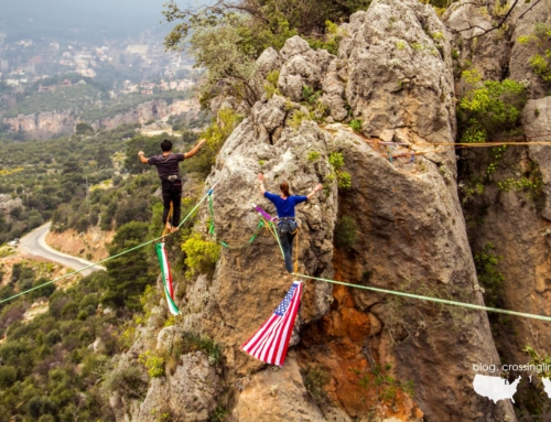
Because standing still is boring.
Mount Lafayette, January ’14.
I’ve never been all that interested in hiking. I like going places, but I prefer going places to do things. I’ll gladly hike a few miles with a 50lb pack to rig a highline overlooking the valley, or climb, or jump off of a bridge. So why am I hiking these adorable hills the locals call mountains?* Because I need the practice. I want to see how far I can walk. How cold I can get. How well my camera holds up in winter conditions. How well I read the weather, the trails. What sort of decisions I make when I’m cold and hungry and tired.
We’re going to Iran to slackline. In preparation, Jade and I bought a Lonely Planet Iran travel guide and a Farsi phrase book. We know we’ll be doing some climbing while we’re there, in part to set up the highlines, so we’ve both been amping up our game in that realm too (mostly relegated to the gym during the cold weather), reviewing John Long’s climbers bible, Climbing Anchors and generally daydreaming the work day away. One day we’re sitting in our favorite little coffee shop and making plans and excitedly reading through the newly arrived travel guide when I stumbled upon the mention of Mount Damavand suggested as an activity only for ‘adventurous’ travelers. Reading on the book describes the potentially active volcano pocketed with hot springs, a common guided hike in the summer. A tourist attraction. But in the winter…
With barely a second thought a winter summit of Mount Damavand was added to the agenda. I guess technically it won’t quite be winter, rather late fall if we stay on schedule, but conditions will be similar. Only one problem. While I’ve been ice climbing for a year now, and grew up in the mountains of Montana, I haven’t done much serious winter hiking or true mountaineering. While Jade grew up hiking volcanoes in El Salvador and has done many of the Adirondacks, only a few of those were in winter conditions. And while Damavand may be a tourist attraction as a summer hike, especially on the stair stepping southern route, in winter this non-technical climb is a legitimate alpine excursion due to serious winter conditions. At 18,406 ft (5,610m), Mount Damavand isn’t going to be just a day hike in beautiful weather. So, we prepare as best we can with our New England mountains (Adams and Washington are next) and we’re planning more serious summits between now and October, waiting on plane tickets and scheduling. Meanwhile, Freedom of the Hills has taken over permanent residence in my bedside book pile and my wishlist for gear has grown to include better thermal underwear and new trekking poles.
A week after returning to Boston from holiday in Montana, I met up with a slackliner friend, Rusty, and his hiking partner, Pat for my first New England summit hike, Mount Isolation. Round trip ~12 miles, estimated 9 hours in good weather conditions. We made it in 8, in good humor and without rushing at the summit and were quite proud of ourselves. We crossed the river four times, though only two were necessary, laughing when we realized our mistake after frog hopping the last gap only to see the trail reappear on the side of the river we’d just left. For a long stretch the trail through a snow covered marshland was not visible at all, discernible only because by staying on the invisibly packed snow we could avoid post-holing with every step. The last half mile of the ascent was decently steep, consisting of snow covered ice, but we were rewarded with the rapid slide back down the same stretch after our chilling photo session on the summit. The wind at the summit of Mount Isolation rivaled the gales I grew up with on the empty great plains. Rusty, Pat, and I leaned into what we estimated as 60 mph wind, dancing as it pushed us around the ice and moss covered rock. Because why not dance on the top of a cold windy mountain?

Rusty waiting for me at the next cairn, decending Lafayette.
With Rusty McStix, January ’14.
The next week both Pat and Jade were otherwise committed so Rusty and I took on the Franconia ridge loop alone with an oversized bag of trail mix as a constant companion. On both mini-adventures the hike was calm and clear most of the distance, wind only appearing in force as we cleared the treeline onto the summits. On Lafayette the wind served only to blow snow painfully into our exposed faces as we walked the ridge, thus the bright red appearance in my photos above, and to hide our route with drifting snow turning trees into psuedo-cairns on the descent serving to mask our path. The second cairn we found turned out to be a snow covered tree and we backtracked. Visibility was just starting to clear up when a group of six or seven hikers appeared out of the fuzziness, passing us on their approach and leaving a blatantly clear trail for the rest of our decent to the treeline despite the wind threatening to hide it once again.

Go where there is no trail.
I’ve discovered I like hiking in its own right, especially in the winter, especially in good company on empty trails. It is difficult to be stressed out about work or life, to be upset or irritated, to be anything other than alive while in the woods miles away from the sound of a car or someone trying to sell me something. Especially when my hiking partner is yodeling into the empty spaces.
For now I’m hiking to prepare for Mount Damavand. But why summit Damavand at all?
Because I’ve only ever hiked a known trail, followed someone else’s lead, gone to the well traveled places, played it pretty safe. Because I dreamed recently about endless white, footsteps in the snow. The footsteps were only behind me. And I smiled.
~~~

Jade at the summit of Whiteface Mountain, 2012.
Photo by Kristen Vitro.
— Jade wanted to be in this blog too, so here’s a picture of Jade at Whiteface Mountain. She’ll write her own blog post soon, Mount Adams report perhaps?
(*Ok. To be fair, 60 mile an hour winds and below freezing temperatures at the summits do the name credit, but having grown up in the west I think I’ll always have a hard time looking at these cute rounded lumps and calling them mountains.)


Leave A Comment